Dominating the Numbers
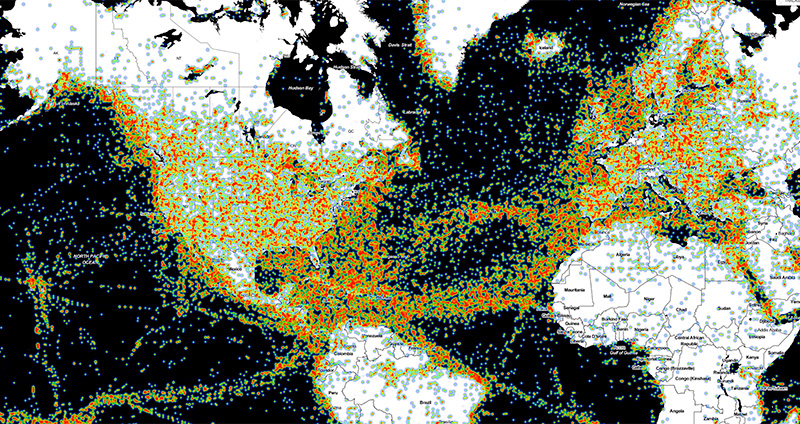
Navionics is the most award-winning company in the marine electronics industry. However, it’s our customers who really matter. Because they have made our plotter cards and mobile apps their first choice, Navionics has become the best-selling cartography in the market. We introduced crowdsourcing in the marine and lakes industry and connected plotter to mobile, enabling us to launch a new generation of products and services. Each person’s contributions are integrated with existing chart data to generate a superior level of detail for all boaters. This year, we surpassed 1,7 million sonar logs received from the boating community in every region of the world. With Navionics, users have access to the largest privately-held database of marine and lake charts in the world.
Current Charts Anytime
Only Navionics customers can enjoy a unique benefit: the most current charts every time they go boating. Our Nautical Chart is updated with more than 2.000 edits per day. Last year, Navionics integrated 58.965 inputs to Central & West Europe (46XG), 48.364 to Mediterranean & Black Sea (43XG), 43.883 to UK, Ireland & Holland (28XG), 49.778 to Baltic Sea (44XG), 49.511 to Skagerrak & Kattegat (45XG), 37.342 to Norway (49XG). Many more were added throughout the world, including Middle East, Africa and America. In addition to these, several hundred thousand edits to SonarChart™ and Community Edits were also integrated and made available for both plotter and mobile charts. Enabling customers to keep their charts up to date is a primary focus for the company. This is why every Navionics product includes one year of daily updates. Customers who own old cards have several options to update their charts, at up to 50% discount! They can ask their dealer about update and upgrade options or visit our website to update their old card online. New this year, customers can get a brand new card in a very easy way once their subscription has expired. We’ll ship it preloaded and activated, with one year of daily updates and advanced features.
Plotter and Mobile Integration
More and more customers new to boating learn the importance of cartography by first downloading our app, which has been at the top of marine navigation rankings all year. And, when in need of a GPS plotter for their boat, they choose a Navionics compatible device. Not only will they get the same detailed cartography and superior content on both plotter and mobile, but they can also download chart updates via the mobile connection, transfer routes and markers, upload data to improve their charts, and create their own HD maps. A growing number of plotters, including many new Wi-Fi models, are now compatible and our systems are easier to use than ever.
Powerful Advanced Features
Dock-to-dock Autorouting, SonarChart™ Live, Advanced Map Options and Plotter Sync, innovative advanced features introduced in the past few years on mobile and plotter, are getting continuous customer traction. The rising interest from boaters has prompted plotter manufacturers, such as Raymarine, Lowrance, Simrad and B&G, to add compatibility via software updates to a wide range of plotters that are currently in use, including many of their latest models. Now, all the Elite Ti from Lowrance enable SonarChart™ Live, Advanced Map Options and Plotter Sync. The newly introduced Lowrance Hook 2 comes with SonarChart™ Live and Advanced Map Options. Raymarine Axiom and Axiom Pro models, powerful new multifunction navigation systems, also support the Navionics advanced features (Plotter Sync coming soon). Axiom are the first models to offer our One-click Dock-todock Autorouting, allowing users to create a route by simply tapping their destination.
Web API
Navionics Web API allows charts to be incorporated into any third-party website. More than 1.000 publishers, dealers, fishing clubs, charter organizations and regatta organizers use it to better engage their customers online. This year, Volvo Ocean Race adopted the Navionics Web API so fans can follow each leg of the race as the competitors sail around the world. Websites can add any kind of graphic overlays, such as service locations or moving objects. Dealers can also incorporate our product catalog. Implementation is easy. For more information, visit https://webapiv2.navionics.com/.
Mobile SDK
During late summer 2017, Navionics introduced a software development kit (SDK) which enables a growing number of iOS app developers to integrate our charts within their mobile apps enriching the user experience for sailors, anglers, divers and boating enthusiasts.
Events and Dealers
We will continue to increase our involvement within each territory. Each year we are participating in more events to educate boaters about our products. The result of this added visibility is increased awareness and demand. At the dealer level, our representatives are always available to support promotions and initiatives. Looking ahead to 2018, you’ll see a new visual identity for Navionics, first in our restyled booklet and website. We also offer our dealers dedicated posters with cartography of their area, POP, as well as the new “Navionics Updates Center” sticker.
About Navionics®
For more than 30 years, Navionics® has developed and manufactured electronic navigation charts and systems for marine, inland lakes and rivers, and outdoors use. Navionics, based in Viareggio, Italy, operates its US headquarters in Wareham, MA, and worldwide offices in the UK, India and Australia. Navionics, acquired by Garmin® Ltd. in October, 2017, will continue to offer its products and services to all marine electronics industry leaders with the same confidentiality and increased enthusiasm and commitment.