
High-resolution relief shading for U.S. coastal waters and more than 150 lakes is now available for Navionics customers to enjoy on their mobile devices and compatible GPS chartplotters.
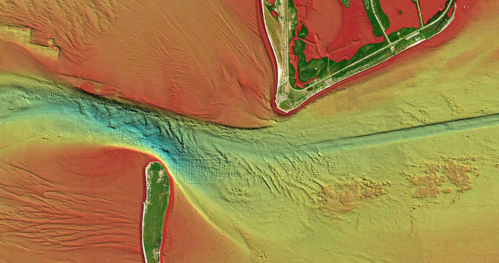
Relief shading combines color and shadow to present an easy-to-interpret, clearer view of bottom structure than contour lines alone. Created from multibeam surveys and other high definition data, the Navionics relief shading feature brings bottom detail to life, from shallow flats to deep offshore canyons, in a vivid, colorful representation that helps boaters gain a better understanding of bottom topography for better fishing and diving experiences.
Apple and Android Mobile Devices
With the latest version* of the Navionics Boating app, relief shading becomes available as an additional overlay. Customers with an active subscription can simply download their area of interest, turn on the new overlay and dive in. *Availability of app updates varies by platform and may be delayed slightly for Android devices.
Chart Cards for GPS Chartplotters
Designed with the most demanding boaters and serious anglers in mind, Platinum+ and HotMaps Platinum charts are already preloaded with satellite overlay and SonarChartTM Shading, 3D View, and panoramic photos to provide the ultimate situational awareness, while also offering Navionics+ marine content, advanced features and daily updates for one year. High-resolution relief shading adds a whole new perspective. And, it can be viewed using adjustable transparency with other Navionics chart layers, such as SonarChart 1’ HD contours, for a richer, more informative display. An active subscription is required to download relief shading from navionics.com using the Navionics Chart Installer.
Currently, relief shading is available for much of the U.S. inland lakes, the East Coast and the Gulf of Mexico, with more areas soon to come. As coverage areas are released, customers who own the Navionics Boating app, Platinum+ or HotMaps Platinum charts with an active subscription will be able to download it.
GET RELIEF SHADING
With an active subscription
- Have a plotter card? Plug your card into a PC and download the relief shading overlay where desired using our Chart Installer. Upon download of any relief shading area, the existing overlay for the entire coverage area will be removed from your card. Note: to ensure chartplotter compatibility, only one overlay may be hosted on a Navionics card at a time, but you may return to swap overlays as long as your subscription is active.
- Have the Boating app? Update the app to the latest version. Open the app and tap Menu > Download Maps > define the download area > tap “+” > Select Relief Shading > Download. To select the overlay, tap Menu > Map Options > Relief Shading
With an expired subscription
- Have a plotter card? Choose one of the available options to easily renew.
- Have the Boating app? Relief shading is only available with an active subscription. On this website, log in with the same account you use in the app. In the top menu select the Account icon > Subscriptions and Renew. Inside the app, tap Menu > Me > Subscription.
IF YOU DON’T HAVE NAVIONICS YET
- Have a plotter? Choose Platinum+ or HotMaps Platinum
- Have a mobile? Download the free Boating Marine & Lakes app, which provides a free trial


