Up to 5,000 updates every day
Up to 5,000 updates every day
See Recent Examples of Updates
- ASIA
CINA
New/Updated Shoreline
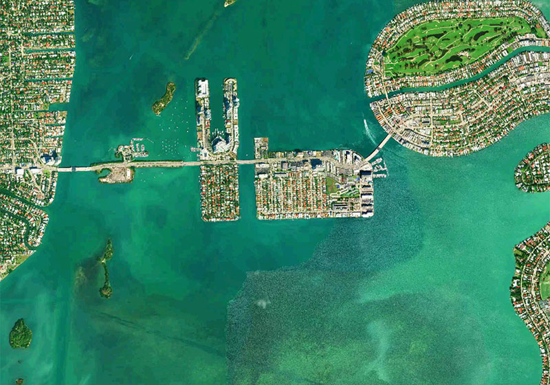
- Tianjin, Shanghai
AFRICA & MIDDLE EAST
SOUTH AFRICA
New/Updated Marina
- Rust de Winter
- Albert Falls Dam, Arabie Dam, Clanwilliam Dam, Injaka Dam, Vaal River
New/Updated Chart Overlay
- Albert Falls Dam, Arabie Dam, Clanwilliam Dam, Injaka Dam, Roodekoppies Dam, Rust de Winter Dam, Vaal River, Vygeboom Dam, Witbank Lake
EUROPE
CROATIA
New/Updated Marina
- Skradin
New/Updated Bathymetry
- Hvar Island
Other Improvements
- Trogir
CZECH REPUBLIC
New/Updated Lake/Inland Waters
- Vodní nádrž Lipno
DENMARK
New/Updated Chart Overlay
-Bornholm
FRANCE
New/Updated Lake/Inland Waters
- Lac de Rabondages, Lac de Venables
New/Updated Chart Overlay
- Porto Vecchio, Lac de Venables
GREENLAND
New/Updated Bathymetry
- Alluitsup Paa
IRELAND
New/Updated Chart Overlay
- Aran Islands
SWEDEN
New/Updated Lake/Inland Waters
- Lurö Skärgård Nature Reserve, Roxen Lake, Unnen, Vänern, Vättern
New/Updated Protected/Restricted area
- Kattegat
SWITZERLAND
New/Updated Chart Overlay
- Lake Silvaplana
THE NETHERLANDS
New/Updated Shoreline
- Waddenzee
UNITED KINGDOM
New/Updated Bathimetry
- Medway
New/Updated Chart Overlay
- Bristol Channel, Plymouth
NORTH AMERICA
CANADA
New/Updated Lake/Inland Waters
- Quebec: Champlain Lake, Lac Laverdière
- Manitoba: Bird Lake, Booster Lake, Great Falls Reservoir, Lac du Bonnet, Pine Falls Reservoir, Red River Lockport to St. Norbert, Winnipeg and Lower Red
- Ontario: Lake of the Woods (Labyrinth, Bishop and Red Cliff Bays), Lake Shabomeka, Ontario, Rush Lake, Rainy Lake, Upper Black Sturgeon Lake
- Saskatchewan: Crew and Torrance
- New/Updated Chart Overlay
- British Columbia: Central Coast
- Nova Scotia: Cape Sable Island
UNITED STATES
New/Updated Lake/Inland Waters
- Arkansas: Lake Conway
- Florida: Keys - Reef Improvements
- Georgia: Allatoona, Blue Ridge, Harding, Nottely
- Kentucky: Lake Barkley
- Illinois: Red River Pool 4
- Louisiana: Grand Bayou Reservoir
- Michigan: Elk Lake, Hamlin Lake
- Minnesota: Dead Lake, Kabetogama, Lake Traverse, Morrison Lake
- New York: Lake Champlain
- North Dakota: Devils Lake
- Oklahoma: Ellsworth Lake, Eufala Lake
- Tennessee: Normandy Lake
- Texas: Bois D'Arc Lake, Cypress Springs, Eagle Mountain, Grapevine Lake
- Vermont: Lake Champlain
- Wisconsin: Arkdale Lake, Clear Lake, Cranberry Lake, Fox Lake
New/Updated Bathymetry
- Alaska: St George Island
- New Jersey: Champlain Lake
- Vermont: Champlain Lake
New/Updated Chart Overlay
- Arkansas: Beaver Lake
- Connecticut: Long Island Sound
- Florida: West Palm Beach Area, West Palm Beach, Pourtales Terrace, Straits of Florida
- Georgia: Chatuge
- Maine: Great South Channel
- Massachusetts: Great South Channel
- Minnesota: Kabetogama
- Montana: Branham Lakes, Koocanusa
- New Hampshire: Arlington Mill Reservoir
- New York: Lake Champlain, Long Island Sound
- New Jersey: Manasquan Reservoir
- North Carolina: Blue Ridge Lake
- South Carolina: Monticello Reservoir
- Tennessee: Normandy
- Texas: Castle Rock Lake, Cypress Springs, Eagle Mountain, Grapevine Lake
- Washington: Crescent Lake, Columbi River Estuary
- Wisconsin: Petenwell Lake, Castle Rock Lake
PACIFIC
AUSTRALIA
New/Updated Lake/Inland Waters
- Blue Rock Lake
- Glenlyon Dam
- Lake Atkinson
- Lake Barambah
- Lake Burredong
- Lake Carcoar
- Lake Coperton
- Lake Dyer
- Lake Hume
- Lake Keepit
- Lake Mulwala
- Lake Proserpine Boondooma
- Lake Windamere
- Lake Wivenhoe
- Lake Wyangala
- Leslie Dam
- Monduran
- Split Rock Reservoir
- Victoria Pykes Creek Reservoir
New/Updated Bathymetry
- Corner Inlet
New/Updated Chart Overlay
- Tasmania
SOUTH AMERICA
New/Updated Lake/Inland Waters
- Suriname
New/Updated Marina
- Saint Martin
Other Improvements
- Aruba, Bonaire, and Curaçao
How We Work
New Data Sourcing
We integrate all sorts of new data from official hydrographic services and private entities. Our aim is to generate a comprehensive product that goes well beyond official HO charts. This is why we constantly scout new sources and carefully select the content that ends up in our final product. We choose different sources for different areas in order to maintain our high standards and continue serving our customers with the best detail possible.
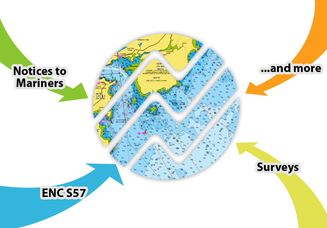
Integration and Processing
Only Navionics delivers updates in such an incredibly timely way. On average, we integrate new data within 15 to 30 days from publication by the original source. New data include, but are not limited to:
- Notices to Mariners
- ENC data S57
- surveys
- and more
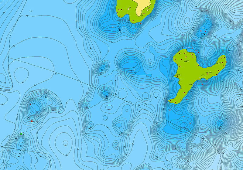
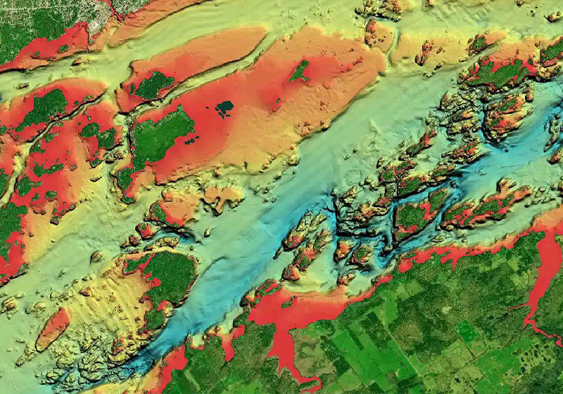
SONARCHART CONTOURS
SonarChart™, our 1' HD bathymetry layer, is constantly enhanced by millions of sonar logs from boaters like you. These new contributions, coming from all over the world, are integrated with existing data to reflect the ever-changing conditions of sea, lake, and river bottoms at a very local level.
CHART OVERLAYS
Satellite imagery, Relief Shading and Sonar Imagery chart overlays are updated periodically as new or better source data is acquired and integrated, allowing us to deliver expanded coverage and improved quality.
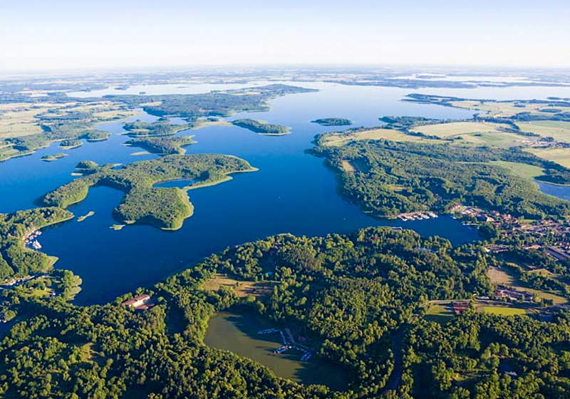
LAKES
Navionics charts include more than 40,000 lakes worldwide. But that’s not all of them. We constantly source new data, so no matter where you are, you can boat and fish at a lake nearby.
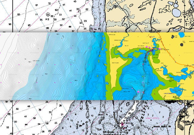
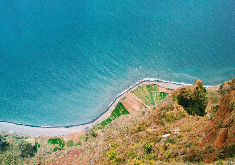
SHORELINE UPDATES
The forces of nature, as well as construction projects like dams, dredging and marina development, affect the shape of coastal, lake, and river shorelines. Our experienced cartography teams meticulously review and redraw these features as they change over time.
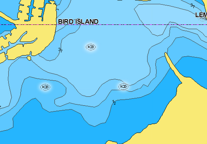
FISH ATTRACTORS AND ARTIFICIAL REEFS
Build it and they will come. Fish seek out particular types of habitats where they prefer to nest. In many lakes and coastal waters, angling clubs and fisheries organizations will sink structures to attract fish and encourage a healthy fishery.
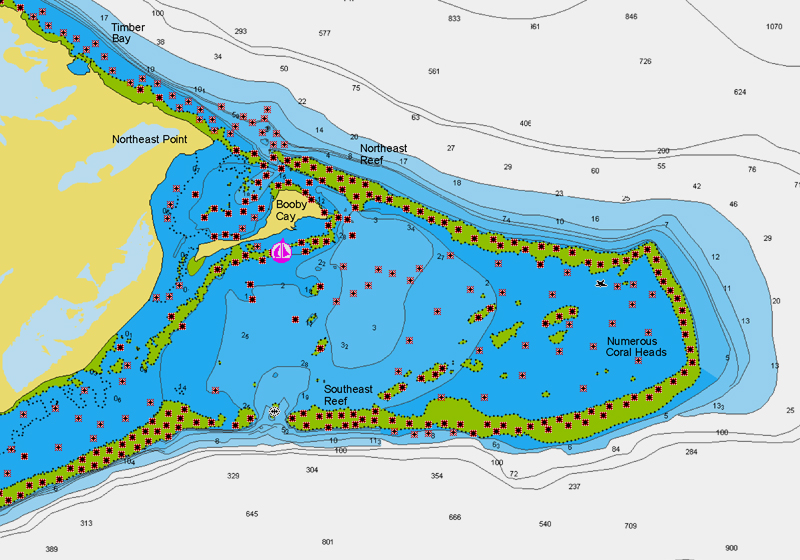
ROCKS AND NATURAL REEFS
Nothing ruins your boating day like hitting a rock. In addition to our own research, we encourage boaters to share the locations of underwater and exposed rocks. These potential hazards are displayed clearly within our products, making boating safer for everyone.
Shoreline Updates
Fish Attractors and Artificial Reefs
Rocks and Natural Reefs
Update Any Time You Want
GPS Plotter Charts
With an active subscription you can keep your charts up to date by inserting your card into a PC, directly or using a card reader. You can also do it from your boat using Plotter Sync.
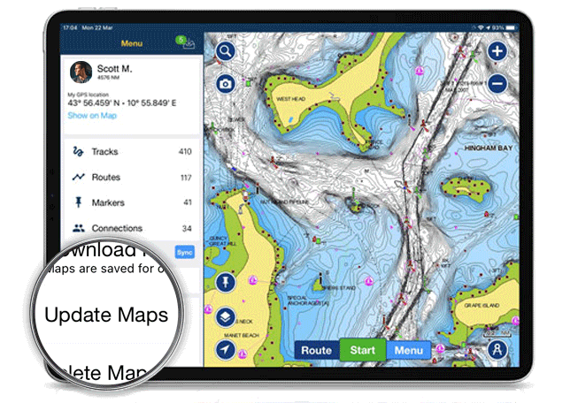
Navionics Boating App
Within the one year subscription, open the app, go to the Menu and tap on Update All Maps.
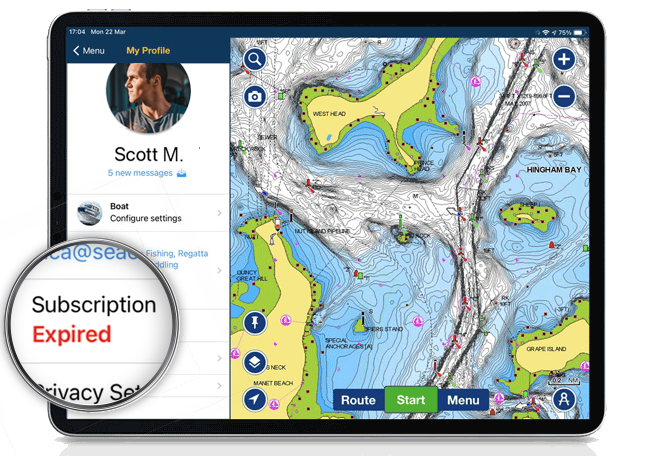
Subscription Expired?
Navionics Boating App
- From navionics.com: go to the Subscriptions section of your account and click on Renew.
- Within the app: Open the app menu and tap on Subscriptions.