
Updates bring high-resolution relief shading to even more global regions and U.S. lakes
Regardless of your reason, or even your nautical experience, there is no better feeling than untying the dock line with complete confidence in your onboard tools. Whether an impromptu cruise to cap off the day, or a thoroughly planned fishing expedition that has been on the calendar for months, one thing is certain: Garmin’s marine cartography is an invaluable tool, not just an accessory. Game-changing hardware combined with the brilliant detail of Navionics® data create the ultimate dynamic duo for those longing to escape the ordinary. And, especially during a global pandemic, a day out on the water is the perfect getaway.
Garmin’s latest cartography update, v2021.0, provides boaters and anglers of any skill level with the gear they need for whenever they hit the water next. The update expands mapping coverage for Garmin users, adding new and updated charts and features for specific regions across the globe.
Here’s a breakdown of what to expect in v2021.0 cartography:
New regions add high-resolution relief shading
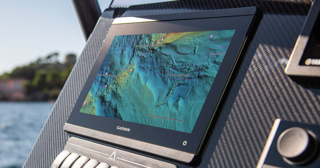
For the first time, BlueChart® g3 Vision® card owners off the coasts of Europe, Australia and New Zealand1 have access to high-resolution relief shading content for their compatible Garmin chartplotters. In these added regions, card owners can easily download high-resolution relief shading layers directly to BlueChart g3 Vision cards, via the ActiveCaptain® app2, in search of fish-holding structures, artificial reefs, underwater shelves or flat fishing spots. The ActiveCaptain app provides a simple yet powerful way to access this new chart layer and manage your marine experience, on top of other valuable functions such as the connected ActiveCaptain community.
High-resolution relief shading — a preloaded feature for BlueChart g3 Vision and LakeVü g3 Ultra cards in U.S. territories — combines color and shadow for a clear, easy-to-interpret view of the ocean floor or lake bottom. When displayed on your Garmin chartplotter, vivid colors and contours help reveal unique diving locations or the best spots to snag your next trophy catch, right at your fingertips.
In June Navionics launched high-resolution relief shading for its Platinum+ and HotMaps Platinum cartography products3 and the Boating app4. Navionics also updated and expanded coverage for the SonarChart™ Shading overlay and refreshed satellite imagery, offering a full suite of rich bottom topography.
New Garmin heatmap
Accompanying the release of v2021.0 cartography, Garmin is unveiling a “heatmap” that allows users to compare the quantity and position of chart updates from one cartography version to another. The new Garmin heatmap stretches the globe and provides a clear visual of the countless updates following each new cartography release. Numerous factors can contribute to altered lake and ocean floors, such as weather or marina development, which means that it is always important to have the latest chart content. Garmin’s heatmap scopes out exactly where and how often updates are made to charts so you always know you are getting the most thorough and high-quality cartography content.
Marine navigation charts have never been more clear or easy to interpret than with the comprehensive coverage and detail of integrated Garmin and Navionics cartography. Cartography, as mentioned before, is an essential onboard tool. Fortunately, the release of v2021.0 is the perfect addition to fuel your exploration — and confidence — on the next trip you take to lake or sea.
BlueChart g3, BlueChart g3 Vision, LakeVü g3 and LakeVü g3 Ultra cards featured in this cartography release are compatible with Garmin chartplotters, such as the GPSMAP® 8400/8600 series, as well as other Garmin devices, such as the quatix® 6 series marine smartwatch. Click here for more information on chart cards, features and compatibility.
1Feature download required


