SonarChart Shading is a new chart feature we will be adding to our exclusive Platinum+ cartography products for coastal fishing and boating.
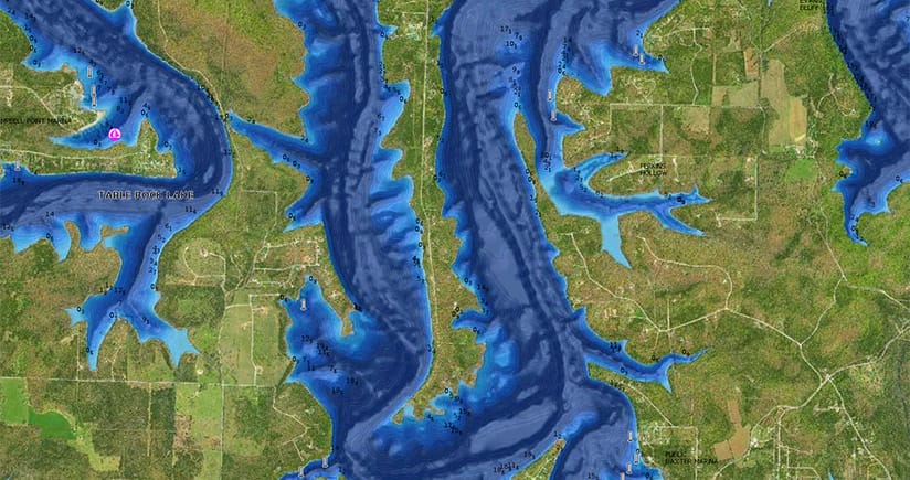
Embedded within the satellite overlay content layer, SonarChart Shading provides a detailed rendering of the seafloor to deliver a unique perspective of underwater topography at a glance. Created from the high-definition 0.5 meter contour data within SonarChart, varying shades of blue reveal changes in depth, highlighting channels, drop-offs and other features to give you better situational awareness and clear, visual cues to identify fish-holding structure.
SonarChart Shading can be viewed on GPS chartplotters that are compatible with Platinum+ satellite overlay and with the same options, including selectable overlay on land, land and shallows, or full overlay. Adjustable transparency allows you to view the new imagery blended with either the SonarChart bathymetry map or the nautical chart.
At closer zoom levels, SonarChart Shading is replaced by the actual satellite imagery over water, allowing you to see a bird’s-eye perspective of sandbars, marshes and backwater channels. In addition to SonarChart Shading, Platinum+ will offer updated and optimized high-resolution satellite imagery. As coverage areas are released, customers who own a Platinum+ or HotMaps Platinum chart with an active subscription will be able to download the combined satellite overlay and SonarChart™ Shading layer for their region via the Chart Installer.
We expect to release SonarChart Shading starting in mid- spring with HotMaps Platinum for U.S. and Canada. Coastal coverage will follow with updated Platinum+ marine charts for U.S., Europe, Canada and Central America, then South America and Australia by midsummer 2019. Availability for other regions is expected by Q4 2019.