
At Navionics, we continuously enhance our products and technology to provide our customers with the best possible experience, the most complete details, and relevant content. As part of our ongoing product enhancement, we recently integrated new data on 34 Texas lakes.
We understand how important good mapping is to anglers who launch their boats on the great fishing lakes in Texas. We recently acquired new data, such as shoreline details, bathymetry and multi-beam sonar on many of them, and we reviewed our existing charts and carefully integrated the new content within the Nautical Chart and SonarChart layers.
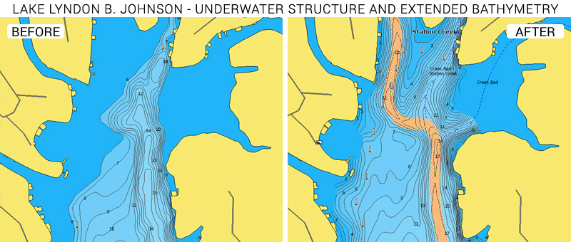
Lake Lyndon B. Johnson, one of the Highlands lakes formed from the Colorado River outside Austin, and Joe Pool Lake, just southwest of Dallas, both now reflect improved accuracy and detail from recent multi-beam surveys. Some of the changes are quite noticeable, such as the Station Creek area of Lake Lyndon B. Johnson where the bathymetry extends closer to the shallow near-shore waters, and underwater creek channels are clearly marked. Numerous docks are now outlined, giving anglers more places to cast out for the largemouth bass, white bass, crappie, and catfish who inhabit in these waters.
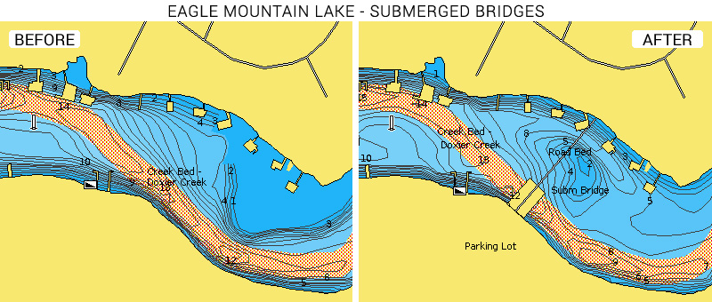
Eagle Mountain Lake, northwest of Fort Worth, offers excellent fishing opportunities for crappie and white bass, as well as largemouth and spotted bass.
In addition, our customers will find updated coastlines and bathymetry on the following lakes:
- Alvarado Park Lake
- Barber Lake
- Beals Creek
- Big Creek Reservoir
- Boerne Lake
- Brady Creek Reservoir
- Brandy Branch Reservoir
- Lake Bryan
- Lake Bryson
- New Ballinger Lake
- Lake Catharine
- Champion Creek Reservoir
- Clyde Lake
- Lake Cooper
- Lake Daniel
- Johnson Creek Reservoir
- Lake Diversion
- Harris Reservoir
- Lake Mineral Wells
- Mountain Creek Lake
- Twin Oak Reservoir
- White Rock Lake
- Valley Lake
Several other lakes now contain improved bathymetry:
- Lake Bastrop
- Lake Cherokee
- Lake Gilmer
- Lake Leon
- Marine Creek Lake
- Lake Naconiche
- Purtis Creek Lake
- Wheeler Branch Reservoir
See the improvements now
Browse your areas of interest on our Chart Viewer, check out some examples here below and judge for yourself:

Learn more about chart updates and discover our latest changes!
GET UPDATED CHARTS!
With an active subscription
- Have a plotter card? Plug your card into a PC and download. Or, if you also have our Boating app, do it wirelessly with Plotter Sync. Download
- Have the Boating app? Open the app and tap Menu > Update All.
With an expired subscription
- Have a plotter card? Choose one of the available options to easily renew. Renew
- Have the Boating app? Open the app, tap Menu > Charts & Upgrades.
IF YOU DON’T HAVE NAVIONICS YET
- Have a plotter? Choose Navionics+ Regions South or HotMaps Platinum South.Shop Now
- Have a mobile? Download the free Boating Marine & Lakes app that provides a 2-week free trial or the paid apps for USA!Shop Now


