
Paper charts have been essential to navigation for hundreds of years, but the chartplotter is a gamechanger in the marine world. Today, there are many chartplotter manufacturers and hundreds of models to choose from, so first-timers can be a little overwhelmed. You may have heard of Garmin, B&G, Furuno, Humminbird, Lowrance, Raymarine, Simrad and others, but which one is right for you? Luckily for you, we’ve worked with hundreds of chartplotters in order to make them compatible with our charts, so we can provide you with some advice.
The chartplotter choice is strongly tied to your specific needs. An avid angler will need something different from someone who loves to sail or from a recreational boater. Keep your needs in mind and start building from that. Let’s start with the basics.
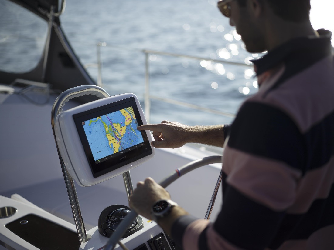
THE SCREEN – Size, readability, and touchscreen
One of the first things to consider when purchasing a chartplotter is the screen size. You want to get something that is big enough for your needs but not so big that does not fit your helm. Anglers might want to make sure that the screen is large enough to get a good visualization of sonar, and use a split screen function to see charts and sonar at the same time for better awareness. You will find that many sizes exist, for example a 8-12 inch size is a good fit for a typical bass boat. Of course, as for other tech devices, the cost goes up with the screen size. So keep that in mind if you are on a budget.
You’ll also want to check that the display is one of the latest generations with the best sunlight readability and a full HD in-plane switching (IPS) display with a wider viewing angle. This will allow a clear view even when you are not directly in front of the screen and has a higher color quality for better sonar visualization.
Many chartplotters now have touch screens, but there are still models that include buttons to handle zoom levels and moving among the different menus. Which one is best? It depends on what you feel most comfortable with, so try a few out at your local shop and see what you prefer.
COMPATIBILITY WITH OTHER ELECTRONIC TOOLS
The chartplotter is not only an essential tool on a boat. In fact, they do much more than just plotting a route: many are now multifunction displays (MFDs) where boaters can keep an eye on all of their connected devices. Radars, autopilots, AIS receivers, transducers are just a few of the many things that can be present on a boat. All of this can be connected to the chartplotter and managed through it, but to do so, they need to be compatible.
If you bought a boat with electronics already installed, make sure your new chartplotter is compatible or learn more about digital switching systems that help create compatibility among systems. If instead you need to create an entire system from scratch, your best bet is to use equipment from the same brand or check very carefully the compatibility. Look up especially how many ports are available on the chartplotter, so you’ll know how many systems you can connect. Working with an experienced marine electronics installer can be very helpful here.
Another important thing to check is the NMEA network compatibility. This is used especially for AIS devices - most of the new ones work with the NMEA 2000 network but older devices could still be set on the NMEA 0183.
Anglers will want to make sure that the chartplotter they get is compatible with the latest technology when it comes to transducers and sonar. The right technology for your fishing style is essential to ensure you catch more with less effort.
HELM CONFIGURATON - BUILT IN OR MOUNTED
Depending on the boat you own, you can choose two types of configurations. You can decide to install the chartplotter directly in your helm or use a mount that allows you to easily remove the chartplotter and bring it home. In the first case, you should be aware that the microSD™/SD™ card slot could be in the back of the chartplotter, meaning you might need to extract it from the helm to remove the card to download updated charts. If you choose the second option, make sure the chartplotter comes with a mount or purchase it separately.
LAST BUT NOT LEAST: THE CHARTS
A chartplotter is a great tool for your day on the water, but are you really using it to its full potential without charts? Of course not. There are a few brands out there, but you do not need to look far to find the number 1 in mapping*. We constantly work to create nautical maps for boaters and 1 foot/0.5m HD bathymetry maps for the most demanding anglers. Also, we provide more than 5,000 updates every day and a boatload of very helpful features like automatic routing suggestions and more. When looking for your chartplotter, check our compatibility table to be sure it’s compatible with our charts.
And once you have used Navionics cartography, we guarantee you won’t be able to do without.
We hope that you now have more information to make your chartplotter choice. But if you need more advice, dealers near you will be happy to help out. If you don’t know any, here you can find some that sell our charts and also electronics.
No matter which chartplotter you choose, the Navionics Boating app is a great companion that can add functionality (such as wireless chart updates) and the convenience of planning while away from the boat.


