If you are reading this, it is because you are probably looking for a tool that can improve your boating, sailing or fishing and that you can carry it wherever you go. So, let’s talk about a solution we might have for you, the Navionics Boating app.
What is the Boating app?
The Navionics Boating app is well … an app for Android and iOS mobile devices with the ability to let you plan ahead and best spend your time on the water.
Since the app works on phones and tablets, you can plan your activities from wherever you are. While on the water, all you need to do is take out your device and either use it on its own or sync it with your plotter.
If you want to use the app without Wi-Fi, all you need to do is download the maps beforehand for the area you are interested in. Charts, GPS location and most features can be used offline.
Let’s have a more detailed look at chart layers and some of the main available features.
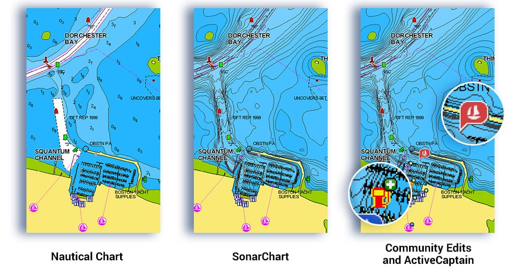
Chart layers provide all the information you need
You have various chart layers available to use while planning or out on the water:
- Nautical Chart: an accurate and thorough map of lakes and marine areas;
- SonarChartTM the 1 foot/0.5 m HD bathymetry map, excellent for increasing awareness of shallow waters and for locating fishing areas;
- Community Edits and Garmin ActiveCaptain Community: useful local knowledge shared by fellow boaters like you.
Plus, we make up to 5,000 updates every day to chart layers so you can always have the most updated maps.
Features and overlays for all types of adventures
The app provides many features so whatever you like to do you can find a helpful tool.
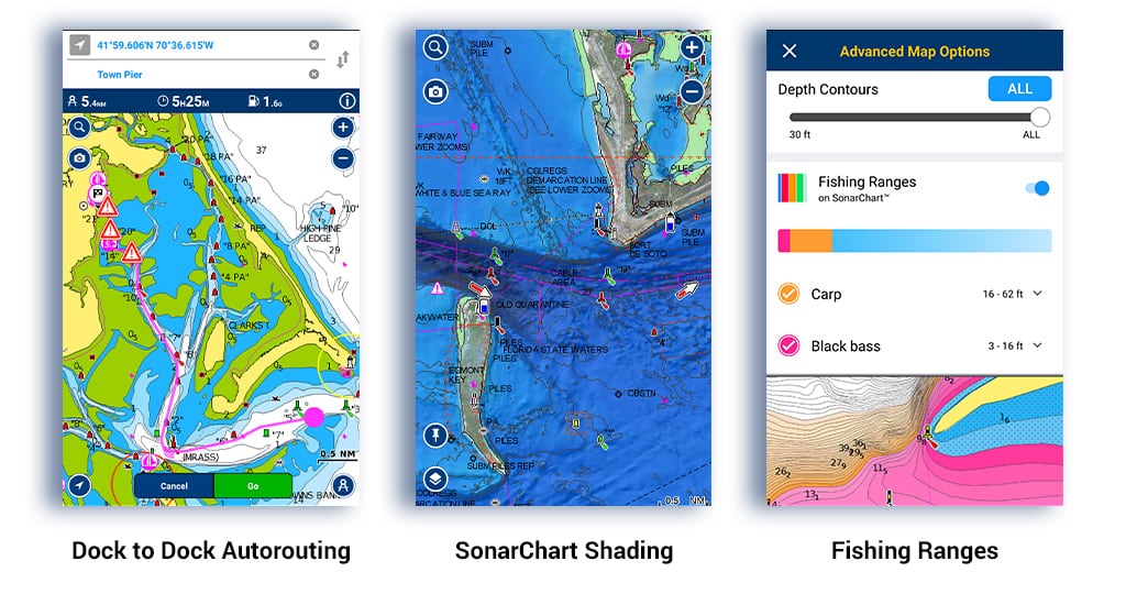
- Dock to dock Autorouting1: need to plan a route? The app can automatically create a suggested route, from a real starting point to a real ending point, based on chart data and navigation aids. It provides advanced route planning with ETA, distance to arrival, heading to waypoint, fuel consumption and more.
- Chart Overlays: you can overlay on chart layers different information like roads and useful points of interest on land, satellite images from Bing, or the new NAVIONICS SATELLITE OVERLAY WITH SONARCHART SHADING. This overlay offers a unique perspective of underwater topography so you can spot fish holding structures at a glance.
- Weather and Tides: knowing what weather awaits you is extremely important in planning your activities. That is why you have access inside the app to real-time weather data along with daily and hourly forecasts, wind, buoys, tides and currents overlaid on your map.
- Map customization: based on your needs, you can customize the map with different tools. You can show contours up to a certain depth, highlight shallow areas, or decrease the number of contours for a clearer view. Fishing ranges even colors up to 5 depth ranges simultaneously for bottom understanding at a glance
- SonarChart Live: create your own map. Just connect the app via Wi-Fi to a plotter or sonar and watch new 1 ft/0.5 m personal HD bathymetry maps develop in real time as your boat moves along the water.
- AIS: increase your situational awareness on the water. See nearby targets overlaid on your charts in real time. Connect the Boating app to a compatible Wi-Fi AIS receiver.
- more features…
Plan on Mobile, go on Plotter
Are you a Plotter owner? Well then you are in luck, the app is the perfect partner for your plotter. With Plotter Sync you can easily connect the two devices via Wi-Fi to transfer routes and markers, update chart layers and more (see compatible Plotters). If your plotter does not have Wi-Fi, you can use the GPX feature to export routes and markers from the app and import them on your plotter card.
How do I get the app?
You can try all the charts, layers and features for FREE for a LIMITED-TIME.
Once your free trial expires, you will have to purchase a subscription to keep using chart layers and most features. Learn more about the subscription.
Try the app now! From a mobile device, tap on your app store button below and download. If you are navigating from desktop, conveniently scan the QR code or follow the instruction on this video.
1Autorouting is for planning purposes only and does not replace safe navigation operations.